Bokora and Matheniko Wildlife Reserves
Bokora Corridor and Matheniko sit among the least visited, least developed protected areas anywhere in Uganda, and understanding why requires understanding what they were actually built for. Gazetted in 1964, both reserves were established not primarily as standalone wildlife-viewing destinations but as a deliberate corridor, ensuring freedom of movement for game migrating seasonally between the Matheniko plains and the Pian Upe reserve further south.
This guide covers both reserves together, since they function as a connected ecosystem, their history, their raw wilderness character, and what a visit actually involves.
Located in Uganda’s Karamoja subregion near Moroto town, the reserves sit within a broader protected corridor stretching from Kidepo Valley National Park in the north down through Bokora and Matheniko to Pian Upe further south, together forming one of the most ecologically important, if under-visited, wildlife migration systems in the country.
Named for the People Who Live Beside Them
Bokora and Matheniko take their names directly from two of the Karamojong tribe’s ethnic subdivisions, the Bokora and Matheniko peoples, who continue to live adjacent to their respective namesake reserves today.
This naming convention extends across the wider Karamoja conservation region: Pian Upe similarly takes its name from the Upe and Pian peoples who live near that reserve, meaning the entire protected corridor reflects the human geography of the communities who have called this landscape home for generations, rather than an arbitrary administrative designation.
Unlike the broader Karamojong population, sometimes historically associated with cattle-rustling traditions, the Bokora and Matheniko people specifically are not known for this practice, a genuine cultural distinction worth understanding before engaging with either community directly.
Bokora Corridor:
Bokora Corridor covers roughly 205,600 hectares (794 square kilometers), positioned between Moroto and Mount Elgon, directly between Matheniko and Pian Upe reserves, making Uganda’s second-largest wildlife reserve after Pian Upe.
Its founding purpose remains visible in its very name and shape: a deliberate corridor of protected land specifically designed to allow game to migrate freely between the Matheniko plains and the Pian Upe reserve rather than being blocked by human settlement or agriculture along the route.
The terrain here is predominantly a dry plateau punctuated by a handful of inselbergs, isolated rock outcrops rising from the surrounding plains, typical of the wider southern Karamoja landscape, with Mount Kadam and Mount Napak standing as the region’s most prominent geological features.
Matheniko:
Matheniko covers a somewhat smaller area, roughly 158,650 to 160,000 hectares, positioned just north of Moroto directly along the Uganda-Kenya border, with the Great Rift Valley escarpment forming much of its eastern boundary.
Historically, this specific area served as traditional wet-season pasture for herds migrating up from southern Karamoja, particularly from the Pian Upe plains, reinforcing the wider corridor’s genuine, functional role in sustaining wildlife movement across the entire regional ecosystem rather than confining animals to any single, isolated reserve.
What Wildlife You Can Expect
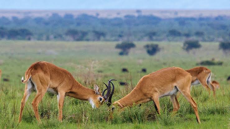
Both reserves hold historically recorded populations of lion, leopard, cheetah, giraffe, eland, roan antelope, and Bright’s gazelle, though current visitor reports describe modest overall wildlife density compared with Uganda’s more famous parks, reflecting decades of reduced management investment in this specific corner of the country.
Ostrich sightings remain reliable, and the reserves are considered among the best places in Uganda to see this species, alongside rarer, more elusive sightings of lesser and greater kudu, Bohor reedbuck, dik-dik, bush duiker, oribi, warthog, vervet and patas monkey, baboon, and jackal.
The Uganda Wildlife Authority has conducted recent aerial wildlife surveys across the combined Bokora-Matheniko system specifically to gather updated population data, part of a genuine, ongoing effort to guide evidence-based conservation decisions and strengthen protection across this historically under-resourced corridor.
Nakapelimoru:
A visit to Bokora and Matheniko offers genuine access to Nakapelimoru, described as the largest traditional cultural village anywhere in East Africa, where visitors can engage directly with Karamojong culture and community life. Nearby, distinctive large sliding rocks offer a playful, low-key activity for travelers wanting a lighter counterpoint to the reserves’ otherwise rugged, wilderness-focused character.
Camping:
There are currently no hotels or lodges within either reserve, and the only genuine way to stay overnight inside Bokora or Matheniko is to bring your own tent and camp, with the Uganda Wildlife Authority providing security and basic ablution facilities for campers. Travelers wanting a more comfortable stay should base themselves in nearby Moroto town instead, roughly a 30-to-40-minute drive from the reserves, and treat a day visit as a standalone excursion from there.
Getting There
The reserves are reached by road from Kampala via Mbale or Soroti, continuing on through Moroto, a long journey reflecting the region’s overall remoteness. There are no airstrips within the reserves themselves, though charter flights can land at Moroto’s airstrip with prior arrangement, offering a considerably faster alternative for travelers prioritizing time over the extended overland journey.
Given the difficult, largely unpaved roads in this region, a 4×4 vehicle is essential, particularly during the wet season, when access becomes considerably more difficult.
Combining Bokora and Matheniko With the Wider Karamoja Circuit
Given their position within the wider Karamoja protected-area corridor, Bokora and Matheniko combine naturally with a visit to Pian Upe Wildlife Reserve further south, a hike up Mount Napak or Mount Moroto, and onward travel to Kidepo Valley National Park for a comprehensive, off-the-beaten-path northeastern Uganda circuit.
This combination suits travelers who’ve already covered Uganda’s more established parks and are specifically seeking the country’s most authentic, least-developed wilderness experience.
Best Time to Visit
December through March and June through September offer the driest conditions, considerably better road accessibility, and clearer chances of wildlife sightings, though visitors should prepare for hot daytime temperatures balanced by noticeably cooler nights, typical of this semi-arid Karamoja climate zone.
Frequently Asked Questions
Why were Bokora and Matheniko originally established?
Both were gazetted in 1964 specifically to function as a wildlife migration corridor, ensuring animals could move freely between the Matheniko plains and Pian Upe reserve further south, rather than being blocked by human settlement.
Is there accommodation within the reserves?
No hotels or lodges currently exist inside either reserve. The only overnight option is camping with your own tent, with basic security and ablution facilities provided by the Uganda Wildlife Authority, or basing yourself in nearby Moroto town.
What wildlife can I realistically expect to see?
Ostrich sightings are reliable, alongside recorded populations of lion, leopard, cheetah, giraffe, eland, and roan antelope, though overall wildlife density is more modest than at Uganda national parks.
How do I get to Bokora and Matheniko?
By road from Kampala via Mbale or Soroti, continuing through Moroto, a long overland journey, or by charter flight to Moroto’s airstrip with prior arrangement. A 4×4 vehicle is essential given the region’s difficult roads.
Can I combine these reserves with Kidepo Valley National Park?
Yes, naturally, given their shared position within the wider Karamoja protected-area corridor, making a combined Bokora-Matheniko-Pian Upe-Kidepo itinerary a comprehensive northeastern Uganda wilderness circuit.